photography

Mountain Creek Trail in Paris Mountain State Park

photo of creek

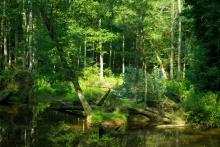
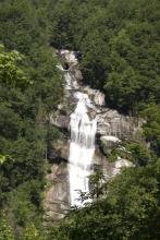
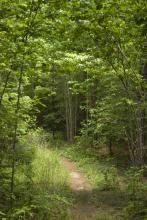
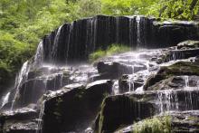
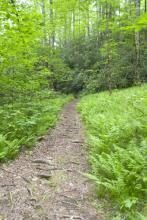
This time, I took a trip along the Mountain Creek Trail, which is part of a series of trails in the Paris Mountain State Park, just north of Greenville, SC. I had not even been aware of this state park, but I found the trails on the web and figured I'd give it a chance. It wasn't a very long trail, only 2.6 miles, but considering the heat wave we've been dealing with, that was about all I was prepared to do. As it was, there was much sweat involved in this hike, and very little of it was due to hiking difficulty.

Photo of creek
Photo of small leafy branch
Photo of leaves
Photo of hiking trail
Photo of leaves
Photo of tulip poplar
Photo of rocky area
Photo of dead tree root
Photo of mossy stump
Photo of tree growing out of a rock
Photo of bent tree
photo of mushroom growing on trunk of tree

Falls and Fungi

The Lower Whitewater Falls Trail starts just short of the North Carolina - South Carolina border on Hwy. 130 from a parking lot of Duke Power's Bad Creek Hydroelectric Station. This 2-mile hike in to an overlook for the falls is moderately strenuous, and provides a series of great views through extremely varied terrain.

photo of trail
photo of rhododendron forest
photo of small fungi
photo of mushroom with water in upturned cup
photo of fern frond
photo of bridge
photo of yellow fungus
photo of waterfall
photo of waterfall
photo of mushrooms
photo of white blooms
photo of waterfall

The Stunning Yellow Branch Falls

photo of waterfall

About 20 miles north of Walhalla, SC is the Yellow Branch Recreation Area, which contains the trailhead for the Yellow Branch Falls trail. This trail winds its way across streams may times before reaching the Yellow Branch waterfall. This trail is about 1.5 miles to the falls, and it is an easy-to-moderate hike.

photo of trees
photo of toad
photo of waterfall
photo of waterfall
photo of waterfall
photo of waterfall
photo of waterfall
photo of waterfall
photo of rock growing around boulder
photo of amphibian
photo of fungi
photo of insect
photo of rhododendron bloom
photo of fallen tree roots

Hiking along the East Fork Trail

Photo of trail through ferns

The East Fork Trail is part of the South Carolina Foothills Trail, an 80-mile trail stretching from Oconee State Park to Table Rock State Park. This section of the trail begins about 20 miles north of Walhalla and follows the East Fork of the Chattooga River. The trail itself is gorgeous, offering views of lush fields of ferns, rushing rapids, and amazing rock faces.

Photo of moss on fallen log
Photo of East Fork branch
Photo of path through ferns
Photo closeup of fern frond
Photo of rocks across stream
Photo of rock face
Photo of stream rapids
Photo of small waterfall
Photo of larger waterfall
Photo of tree growing over a rock

Pages

Subscribe to RSS - photography