hiking

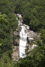
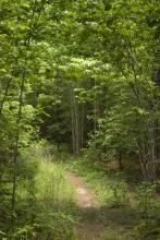
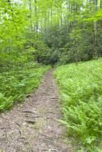
Short and Sweet Trail

Photo of mountain scenery

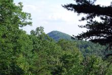
Been a pretty busy June, but I found an afternoon that I was able to get out to hike. I felt compelled to back to the Blood Mountain area of North Georgia. I've hiked up Blood Mountain before, and it's one of my favorite areas to go. There was no time to go up the mountain, but I figured I had time to take a quick excursion up the Byron Herbert Reece Trail, which is only about .7 miles, but it's one of the entry trails to the Appalachian Trail.

Photo of tree roots in dry creek bed
Photo of creek bed
Photo of ferns along trail
Photo of stone "steps" on the trail
Photo of mountain landscape
Photo of boulders
Photo of boulders
Photo of lichen
Photo of mushroom
Photo of intertwined trees

Falls and Fungi

The Lower Whitewater Falls Trail starts just short of the North Carolina - South Carolina border on Hwy. 130 from a parking lot of Duke Power's Bad Creek Hydroelectric Station. This 2-mile hike in to an overlook for the falls is moderately strenuous, and provides a series of great views through extremely varied terrain.

photo of trail
photo of rhododendron forest
photo of small fungi
photo of mushroom with water in upturned cup
photo of fern frond
photo of bridge
photo of yellow fungus
photo of waterfall
photo of waterfall
photo of mushrooms
photo of white blooms
photo of waterfall

The Stunning Yellow Branch Falls

photo of waterfall

About 20 miles north of Walhalla, SC is the Yellow Branch Recreation Area, which contains the trailhead for the Yellow Branch Falls trail. This trail winds its way across streams may times before reaching the Yellow Branch waterfall. This trail is about 1.5 miles to the falls, and it is an easy-to-moderate hike.

photo of trees
photo of toad
photo of waterfall
photo of waterfall
photo of waterfall
photo of waterfall
photo of waterfall
photo of waterfall
photo of rock growing around boulder
photo of amphibian
photo of fungi
photo of insect
photo of rhododendron bloom
photo of fallen tree roots

Lake Jocassee's Raven Rock Trail

Photo of treetops

The Raven Rock trail is part of a small network of hiking trails in the Keowee Toxaway State Park in upstate South Carolina. This trail is a loop trail that branches off from the Natural Bridge loop trail, in the same area. Together, the Natural Bridge and Raven Rock trails form a 4.1-mile loop. The trailhead for these two trails is just off the visitor's center for the park, just off of Hwy. 11, between Hwy. 130 and U.S. 178.

Photo of natural bridge
Photo of tree and rock
Photo of rock vista
Photo of moss-covered rock
Photo of lizard on tree
Photo of root-strewn trail
Photo of Jocassee lake
Photo of lakeside
Photo of trees
Photo of treetops
Photo of tree roots
Photo of waterfall

Hiking along the East Fork Trail

Photo of trail through ferns

The East Fork Trail is part of the South Carolina Foothills Trail, an 80-mile trail stretching from Oconee State Park to Table Rock State Park. This section of the trail begins about 20 miles north of Walhalla and follows the East Fork of the Chattooga River. The trail itself is gorgeous, offering views of lush fields of ferns, rushing rapids, and amazing rock faces.

Photo of moss on fallen log
Photo of East Fork branch
Photo of path through ferns
Photo closeup of fern frond
Photo of rocks across stream
Photo of rock face
Photo of stream rapids
Photo of small waterfall
Photo of larger waterfall
Photo of tree growing over a rock

Pages

Subscribe to RSS - hiking