hiking

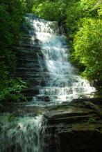
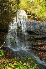
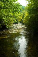
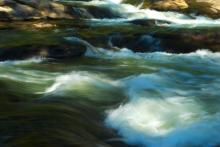
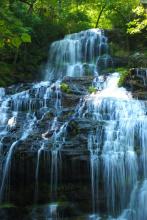
Carrick Creek in Black and White

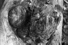
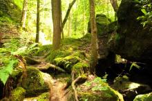
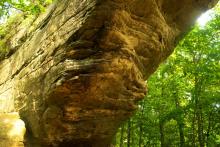
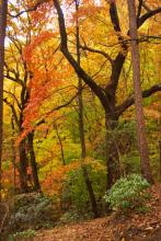
In the middle of December, as things were winding down for the holidays, I took a quick hike over at Table Rock State Park. I had taken the Carrick Creek Loop Trail a few times before, because it is a good overall hike, especially if time is limited. It is about 2 miles (1.8 miles according to guide books) and for the most part it is easy to moderate, with a few stretches of elevation change that ensure that one gets a workout. The recent rains allowed the many cascades and rapids to shine and I decided to render the images in black and white, to emphasize the textures of the subjects.

waterfall
rock wall
waterfall
rapids
small waterfall
tree roots
tree knot

In Search of a Secret

waterfall

In late fall of 2013, I opted to try the Winding Stairs Trail, a 3.5-mile one-way trail in upstate SC. The trailhead I started from is just north of Walhalla, near the Cherry Hill Recreation Area. There is a small parking area there, and it appeared that I was the first to embark on the trail from that end when I got started. I was in search of two falls, Miuka Falls, and the lesser-known Secret Falls. I found at least one of these two.

fall colors
mossy stone
spider web
waterfall
waterfall
fall leaves
fall colors

A Brief Shot of Color

fall colors

So, here it was the middle of autumn, and I very much wanted to get up into the mountains to see the colors of the leaves, which were certainly at their height. I was concerned that if I didn't get up there sometime soon, I'd miss my chance. To that end, I looked around at different trail descriptions, trying to decide on an apt location for leaf-watching. I found a likely candidate in the Hospital Rock trail, a 2.2-mile round trip trail in Jones Gap State Park.

trail
treetops
boulders
waterfall
treetops
hazy mountains
fall leaves
fall leaves
fall leaves
trail
fall colors

Great Smokies Revisited

creek

I opted to return to the Great Smoky Mountains for this hike, since I had some time for a mid-week trip. It's a bit farther than I normally go, since it's a few hours to the park, but when my wife and I had done some hiking in the Smokies during our vacation, I developed an interest in exploring the park further. Thus, I decided to try the Deep Creek Loop Trail.

waterfall
bridge
rapids
stone cairn
rapids
waterfall
roots
treetops
red berries in ground cover
rapids
creek view

What's a Chau-Ram?

rapids

For a number of years now, as I've been living in the upstate South Carolina area, I had seen signs for "Chau-Ram". I kind of vaguely wondered what it was, perhaps thinking it had something to do with the Chauga River. But I never pursued it, until I read a write-up on the hiking trails available there. Turns out, Chau-Ram is a nice-sized park near the confluence of the Chauga River and Ramsey Creek; hence, Chau-Ram.

creek
flowing creek
trail
rapids
rapids
calm water
rapids
river
rainbow in waterfall

Walking into Spiderwebs

waterfall

In late summer, I got a new hiking book, Explorer's Guide 50 Hikes in South Carolina: Walks, Hikes & Backpacking Trips from the Lowcountry Shores to the Midlands to the Mountains & Rivers of the Upstate, and the author spoke of a waterfall called Station Cove Falls that can be reached by way of the Oconee Station Historic Site. This area, located in upstate South Carolina, not far from my home, is one of the oldest frontier stations in the mountains.

reservoir
butterfly
trail
view through trees
trail
tree stump
waterfall
waterfall
waterfall
water surface

Up in the Smokies

mountain view

So, my wife and I, still on our hiking vacation, decided to take some time in the Great Smoky Mountains along the border between Tennessee and North Carolina. After looking through some hiking choices, we opted to go for the Andrews Bald Trail. This trail is about 3.5 miles round trip to a peak that tops out at around 6300 feet. It is a moderate trail, with an elevation gain of about 900 feet, but it's a nice day hike.

Great Smoky Mountains
flower
hiking trail
butterfly
mushroom
dead tree
mushroom
leaves
mountain view
mountain view
blooming flowers
elk

More Wandering in Kentucky

Pile of rocks, boulders and trees

This is a relatively brief post about more of the wanderings in Kentucky that my wife and I did in August of this year. After finishing the Natural Bridge Trail, we decided to do more hiking in the area, and chose the Whittleton Trail. This trail is a 2-mile in-and-out trail that purported to be relatively easy to moderate, and it was just up from Hemlock Lodge, the center of activity in the Natural Bridge State Resort.

rock formation
ground cover
partial rock arch
mushroom
stump
boulders
ground cover
fungus

It's Only Natural

natural bridge arch

A few weeks ago, in late August, my wife and I took some time off. Our wanderings led us to some hiking trails in Kentucky, around the Red River Gorge area. We took an interest in the Natural Bridge State Resort (not sure what the difference is between a State Resort and a State Park, but that's neither here nor there), and decided to wander around and see the sights.

trail
rock formation
red rock
eroded rock
small cave
natural bridge
narrow passage
mountain view
lizard
tree roots
rock face
balanced rock

Angelic Waterfalls

waterfall

As I've done a lot of hiking in and around north Georgia and upstate South Carolina, it has become increasingly difficult to find new day hikes that fit within my schedule and conditioning. So, I picked up a new book, Hiking Georgia, by Donald Pfitzer, to see if I could find some new hikes to try. After a quick sifting through the book, I found the Angel Falls Trail, just over the South Carolina border in northeast Georgia, not far from Clayton, in Rabun County.

waterfall
hiking trail
tree trunk
waterfall
waterfall
fungus
waterfall
small waterfall

Pages

Subscribe to RSS - hiking